
Ontario residents, brace yourselves for a mid-week weather system that's set to bring potential travel disruptions to various parts of the province.
According to meteorologists at The Weather Network, this upcoming storm could make travel conditions treacherous, with the north expecting heavy snowfall and the south facing the threat of freezing rain.
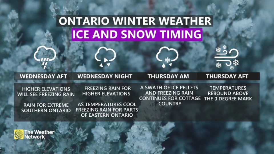
As we approach Wednesday into Thursday, southern and eastern Ontario will need to stay vigilant, as slick roads and isolated power outages could become a reality, The Weather Network said.
In light of this forecast, drivers are being strongly encouraged to prepare for the deteriorating conditions.
If you haven't already swapped out your regular tires for winter tires in southern Ontario, you may want to think twice before hitting the road over the next two days. Patience and adaptability will be key as you navigate the ever-changing weather landscape.
The meteorological setup behind this impending weather event involves a combination of an Alberta clipper and a Colorado low, both converging over the Great Lakes region. This complex interaction is expected to usher in a wintry mix of precipitation, with the exact nature of the wintry mix varying depending on your location.
Particularly concerning are the areas where freezing rain and ice pellets are expected to create slippery roads and potentially trigger isolated power outages. If you find yourself travelling in southern and eastern Ontario late Wednesday into Thursday, it's vital to plan your journey accordingly and be prepared for potential delays on the roads.
Meteorologists are closely monitoring the situation, but there's a degree of uncertainty about the exact placement of the icy elements. The Weather Network notes, "Computer models are having trouble deciding which air mass will dominate, so the exact placement of the icy ingredients continues to fluctuate."
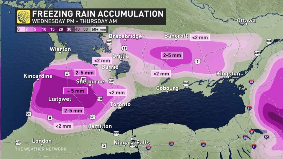
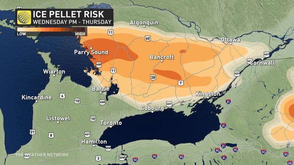
However, one thing is certain: a stagnant area of freezing rain and ice pellets is anticipated to set up east of Lake Huron in southwestern Ontario, extending to Barrie and into eastern Ontario. This wintry mix is expected to impact the higher elevations of the Dundalk Highlands as well.
To the south of this dividing line, encompassing Toronto and the Greater Toronto Area, the primary concern will be rain. However, if you plan to venture out of the city, especially in the evening hours of Wednesday, be prepared for deteriorating travel conditions.
By Thursday morning, warmer temperatures and rainfall should help alleviate the icy conditions in the southern regions. In contrast, eastern Ontario, including Ottawa, is expected to contend with snow overnight, potentially accompanied by a period of ice pellets. While Ottawa is likely to remain mostly snow-covered, the possibility of some ice pellets cannot be ruled out.
🧊 Freezing rain is possible over portions of southern Ontario with the passage of a low pressure system late Wednesday into Thursday! Freezing rain is more likely to occur over areas with higher terrain.
— ECCC Weather Ontario (@ECCCWeatherON) November 7, 2023
View your forecast here 👉 https://t.co/UAXbppiilG#ONstorm #ONwx pic.twitter.com/5zPimROstN
As the mid-week storm approaches, residents are advised to stay updated on weather forecasts, exercise caution on the roads, and make alternative travel arrangements as necessary. Your safety and preparedness will be crucial in navigating the wintry mix that is set to impact different parts of Ontario in the coming days.


